Featured

National Passport Book

As some of you may know, I am a bit of a nerd.  It is a badge that I wear with honor.

My latest nerdy obsession is visiting the more than 400 sites of the National Park System.  The way that I track and organize these visits is with the National Park Passport book.

Passport To Your National Parks® Collector's Edition

In this book, I collect cancellation stamps of sites that I visit.  There are also stamp (sticker) sets that are released every year and have been since 1986.  So basically, you adhere the sticker next to the site and then when you actually visit the site, you stamp it with an ink pad stamp.

2019 Passport® Stamp Set

The NPS is divided into 9 regions.

  • North Atlantic
  • Mid-Atlantic
  • National Capital
  • Southeast
  • Midwest
  • Southwest
  • Rocky Mountain
  • Western
  • Pacific Northwest & Alaska

With each stamp (sticker) set, you get one large stamp that is that year’s National Stamp, as well as one stamp for each region.

Below is a picture of what a visited site looks like.

This image has an empty alt attribute; its file name is IMG_9547.jpg

I find this very cool.  I do have to warn you though, this was a bit of an expensive hobby to start.  The collector’s edition book that I have cost $25.  There is a smaller version for $10.  Then each sticker sheet is $5.  Which doesn’t sound like a lot, but remember, they have been issued since 1986.  34 x $5 = $170.  None of these prices include tax and shipping.  If you want to get started with this, but don’t want to spend more than $200 before ever even stepping foot in a site, then I would suggest purchasing the stamp sets just a few at a time.  Maybe even request them for holiday or birthday gifts.  You can still get your ink pad stamps.  There is no rule saying that you have to have the stickers first.

I will continue to update you all with my progress as I visit as many sites as possible.

LP

Buffalo National River

Visit Date:  September 15, 2019

The Buffalo National River is the second stop in my National Passport Book travels.  There are no fees to go to visit to the Visitor Center, but you may want to call ahead or check their website for camping fees.

The Buffalo was the first National River and was established in 1972 to the National Park System.  This is one of the few undammed rivers in the lower 48 states.

It begins in the Boston Mountains and flows east until it meets the White River.


Visitor Center

The NPS lists 4 places to get your stamp cancellations.  I went to the Tyler Bend Visitor Center to get mine.  This is the main Visitor Center and is open year round.

Inside there was some interesting information about the vegetation and wildlife that thrive in the area.

Just a short walk or drive from the Visitor Center is one of the access points to the river.


Getting My Stamps

IMG_9569


Your Visit

If you are interested in visiting for yourself, you can click here to view the NPS page.


Conclusion

Because the river is 153 miles long, it is one of those things that you could visit multiple times and never see the same thing twice.  What I got to see was beautiful, but I’m not opposed to the idea of returning for perhaps a camping or float trip.


Pea Ridge National Military Park

Visit Date:  September 13, 2019
Address:  15930 E. Hwy 62
                   Garfield, AR  72732

In September of 2019, my family went on our first family vacation in years.  My sister and I live in a different state from our parents, so it is difficult for us all to get together and when we do it is usually a birthday, wedding, or holiday.  And as you all know, those types of events rarely leave time to just enjoy each other’s company.

What started off as an idea for a girls trip to celebrate Mom’s birthday evolved into an all family trip for a double celebration: Mom’s birthday and Dad’s retirement.  Dad retired after 44 years from Remington Arms in Lonoke, AR.  We decided on Branson, MO, for our trip.  Branson is a favorite of Mom and Dad’s and my sister-in-law was somewhat familiar with the area too as she and her family had vacationed there.


Visiting NPS sites

In June 2019, I ordered my National Park Passport book and was excited to start getting some stamps in it.  To learn more about the Passport, click here.  Once we knew we were going to Branson, I immediately started looking at the map to see if I could get in a visit or two.  I was actually able to do three:  Pea Ridge National Military Park, Buffalo National River, and Fort Smith National Historic Site.


The Drive

I enjoy driving because I like seeing things that I would miss if I flew.  Even though I live in Corpus Christi, TX, I decided that I just couldn’t miss out on the beautiful drive through the Ozarks.

I arrived in Branson late on the 12th.  With the timing of my sister and brother-in-law’s flight, we decided to meet up the afternoon of the 13th.  This allowed me some time the morning of the 13th to do some exploring.   The drive to Pea Ridge NMP from Branson was about an hour and a half.  It isn’t that far, but the two lane highway through the mountains is what caused the drive time.  I do regret not having my GoPro mounted on my dash for this drive.  It was absolutely stunning.


Pea Ridge

The city is located in Benton County, Arkansas.  It gets its name from its location on a ridge in the Ozark Mountains and for the hog peanuts (turkey peas) that had been cultivated there for centuries by Native Americans.


History of the Park

The park was created 1956 to preserve the battlefield of the 1862 Battle of PeaRidge. It was dedicated as a national park in 1963 during the nation’s Civil War Centennial.

The Battle of Pea Ridge, also known as the Battle of Elkhorn Tavern, took place March 7-8, 1862 and is generally considered the most important Civil War battle west of the Mississippi River.  The Union army controlled the north and east parts of Missouri while the Confederate army controlled the west and south portions of Missouri and all of Arkansas.  There were many skirmishes that led up to the two day battle at Pea Ridge.  For a more detailed history of the battle, click here.   This was also one of the few battles where the Confederate army outnumbered the Union army.  Union forces defeated the Confederates giving federal control to Missouri and northern Arkansas.  The Union army would continue south eventually capturing Helena, AR.


Visiting the Park

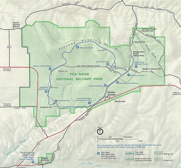
The park is 4,300 acres and is one of the most intact Civil War battlefields.  The entrance fee is $10 per person or $20 per vehicle.  Inside of the Visitor Center is a theater, bookstore, and museum.  Outside of the Visitor Center is a 7 mile tour with 10 stops.  There are also hiking trails and horse trails.  I chose to do the 7 mile drive.  You can access a mobile tour here.  You can click on the stop and listen to a description.  It’s a great way to experience the park at your own pace while getting tour guide quality information.  Below is a map of the tour.

Brochure Map


My Visit

After the beautiful drive from Branson, I started my visit at the Visitor Center.

I went inside to look around the museum and watch the video.

Just outside the rear of the Visitors Center is a remarkable view of the battlefield.


I then began the driving tour.

Stop 1:  Trail of Tears

IMG_5756

This audio describes the conditions that Native Americans endured while being forced westward.


Stop 2:  General Curtis’ Headquarters

Here you will see the sight where Pratt’s General Store stood and get to hear two audios.  One about Colonel Alexander Asboth (Union) and one about Major General Samuel R. Curtis (Union).


Stop 3:  Leetown Hamlet

This audio describes the village of Leetown.  During the Battle of Pea Ridge, some of the buildings were used as hospitals.


Stop 4:  Leetown Battlefield

There are 6 audios for this stop.

  • Leetown Battlefield
  • Colonel Peter Osterhaus (Union)
  • Brigadier General Benjamin McCulloch (Confederate)
  • Colonel Jefferson C. Davis (Union)
  • Brigadier General Louis Hebert (Confederate)
  • Fight in Morgan’s Woods


Stop 5:  Armies Collide

  • Colonel Stand Watie – Leader of the Cherokee Nation that fought for the Confederacy
  • Brigadier General James McIntosh (Confederate)
  • Fight at Foster’s Farm


Stop 6:  Medal of Honor Recipients

This audio describes the four men that were awarded the Medal of Honor


Stop 7:  East Overlook

There is no audio with this stop, but it does have a breathtaking view of the battlefield.


Stop 8:  Elkhorn Tavern

This stop has 4 audios.

  • History of Elkhorn Tavern
  • History of the Cox Family
  • Colonel Eugene Carr (Union)
  • Major General Earl Van Dorn (Confederate)


Stop 9:  Confederate Sunset

  • Captain Francis Herron (Union)
  • Major General Sterling Price (Confederate)


Stop 10:  Federal Line

  • Artillery at Pea Ridge
  • Brigadier General Franz Sigel (Union)


Stop 11:  Little Sugar Creek Trenches

  • Digging in – Trenches at Little Sugar Creek
  • Fight at Dunagin’s Farm


Getting My Stamps

Pea Ridge NMP was the first stop for my Passport book.


Conclusion

I really enjoyed this visit.  Living in Arkansas for most of my life, I had always heard about it.  We even played Pea Ridge in football a few times.  So I was familiar with the city.  But I was not familiar with the in depth history of the area.  Another thing that I have learned from visiting these sites is that I might think that I have zero interest in visiting a place.  For whatever reason, it just doesn’t interest me.  Then, when I get there, I am so in awe.  One of those places is Poverty Point in Louisiana which you will get to hear all about in a later post.  If it wasn’t for this Passport Book, I may have never visited Pea Ridge NMP.  But I am grateful that I did.

Cozumel, Mexico

This was our final stop on the Best Friend Cruise 2016

So we did not get a lot of pictures in Cozumel.  We were more concerned with shopping and eating than touristy sight-seeing.

There is, however, a pretty funny story about our trip to Cozumel.  For most of the day, I had a bit of a sinus issue.  I had to blow my nose a couple of times…you get the picture.  So after our day, we headed back to the cruise ship.  We were almost to the ship when we decided to sit down for a minute to readjust our bags, rest our feet, etc.  On the side of the walkway to the ship was a raised edge; about 1 foot high.  We sat on it, and yes, it was over the water.  As I begin to look for my kleenex to blow my nose, a security guard approaches us and tells us that we cannot sit on the edge.  Now this is where the stories differ…I sternly said to the man that I needed a second because I was having a medical emergency.  Michelle claims that I yelled, but that is not accurate.  Once the man walked away she begins laughing at me and telling me that I am NOT experiencing a medical emergency.  That a runny nose is not that serious.  Now, if you have ever felt snot begin to run from your nose and not had a tissue handy, you can relate to how I was feeling.  #medicalemergency

15202524_10209802568088161_4810140327907009220_n

Above is one of the shops we visited.  We got almost all of our souvenirs in Cozumel.

15095429_10209802568048160_5710637266458044745_n

This is the signature mascot of Señior Frogs.  We had a delicious and entertaining lunch here.  The servers were kind enough to exchange a couple of U.S. dollars for pesos.  I am pretty sure they thought I was weird for that request, but I really like to bring a little foreign money home when I visit another country.


We also got some pics of the water from the walkway.  Some other pics of Cozumel are below.

Laura

San Francisco

Plans changed a bit in San Francisco. We arrived at 4:30am after driving through the night. We made our way downtown to see where we needed to go to get on a tour of Alcatraz. All of our stops we researched before this trip. But we didn’t want to buy too many tickets or reserve hotels in case something happened that set us back. We found out when we got there that tickets to see Alcatraz are sold out weeks in advance.

Then, we had to decide if we were going to wait for the trolley system to open to ride a trolley. We didn’t want to wait so we decided to drive the city ourselves and just use this as an opportunity to get ahead of schedule.

The Drive In

Beautiful bridge on the way in

Sculpture on a corner

Fisherman’s Wharf and Downtown

Neighborhoods, Streets, & Architecture

Known as The Painted Ladies, the pics below may look familiar. They are the houses featured in the opening credits of the original Full House series.

Alamo Square across the street from Painted Ladies

Above and below: large oaks along Oak Street

Cable car lines

One of the tunnels

Videos of us going up and down the steep streets. One of them is one of the steepest in the U.S. with a 17.5% gradient.

placeholder://

The Golden Gate Bridge


The Grand Canyon

We all have seen pictures of The Grand Canyon.  I am telling you, pictures do not do it justice.  To stand before this amazing natural wonder is truly awe inspiring.  We took plenty of pictures, but I am afraid that it can only be fully appreciated by witnessing it first hand.

Getting There

c1

The Visitor’s Center

tgc2

Day 1:

Mather Point

mp1

This lookout is located just behind the visitors center.  It is the busiest lookout point and
serves as a great starting place for visitors.  It was dedicated to Stephen Mather, who was the driving force for establishing the Grand Canyon National Park.  In 1917, he was appointed as the first director of the National Park Service.

mp2

mp3mp4mp5

mp6mp7mp8

mp9mp10mp11mp12

We arrived at the Grand Canyon Wednesday evening.  We drove through the night Tuesday, taking turns sleeping.  So, by the time we got to TGC, we were tired, to say the least.

Originally we had planned to get a campsite for a whopping $18 and just sleep in the truck.  We were really trying to save money where we could because neither of us had ever been on a trip like this and we did not know what to expect.  We didn’t want to waste money on hotels that we would need later for gas or emergencies.  Also, we knew we were going to spend money in Los Angeles, San Francisco, and Seattle.

When we got to TGC, every campsite was booked.  Every. Single. One. Keep in mind, TGC has HUNDREDS of campsites.  We purposely did not want to make reservations because should something happen and we were late arriving, we did not want to be charged.  So we had to start looking at hotel rooms in Tusayan, a community directly outside of the south entrance to the park.  There were several hotels with vacancy.  We found a reasonably priced room at nice little mom and pop place called 7 Mile Lodge.  This place has a 4.6 star rating on google and we gave it a 5.  For just $109 a night, we got a nice, clean room, and the lady at the desk was incredibly friendly.

So after we got checked in, we went back into the canyon park to get the pictures that you see above.  I was surprised at how cheap it was to enter the park.  For just $35, you get a 7 day pass.  In those 7 days, you can leave and re-enter the park as many times as you like.

Once we were done at the park, we stopped at a Mexican restaurant to eat.  Up until this point, we had been eating mainly sandwiches (PB&J, Ham & Cheese, and Turkey).  We also consumed A LOT of crackers.  We will go into greater detail on those later.

We then left to go back to the room to shower and get some rest.  That’s when we saw the elk that is in the videos below.  There were actually two of them, a male and a female, but I believe you can only see the male in the videos.

There were some other interesting happenings this day.  For example, I purchased hotdogs and marshmallows, because what is a night of camping without a campfire and roasted deliciousness?   Well, in case your like me and the rest of the human race, save your money.  Campfires are not allowed in the Grand Canyon.  So even if we had gotten that 5 star campsite, we would have had to have raw hotdogs and marshmallows.

Also, I recommend listening intently to the park ranger when he is giving you a list of information at the entrance.  According to Michelle, the ranger informed us of a 30 minute delay getting to the visitors center due to road work.  I never heard this important information and got quite irritated when we got stuck in the road work.

This was the day that Michelle and I had our first argument.  Road tripping with someone on limited sleep and cheap food is a recipe for aggravation.  Once we got back to the room after eating, we apologized profusely to each other.  This would not be that last disagreement, but by the end of the trip, we were able to recognize them coming on and we were able to laugh at them.  If there is only one piece of advice that you take from us, it is this:  You had better really love someone before you get in a car with them for 10 days.

Day 2:

y1

y2

y4

y6

y8y9

y10

yy1

yy2

yy3

After we left TGC, we headed to our next stop, Winslow, AZ.

Selfie pictures were taken with this selfie stick from Amazon.  It is a bluetooth selfie stick that also has a tripod.

Phoenix, AZ

Phoenix was our second capital for the trip. We spent more time looking for a place to park than actually taking the picture. I was totally fine with parking in a Representative’s parking spot, but Michelle thought that would be wrong for some reason. It was 4:30 pm. If dude wasn’t at work then, he wasn’t going to be. So then I decided to just use the bus loading zone directly in front of the capital. Again, I thought it was fine. Michelle has parking issues.

We’re not sure why this pic was taken driving from the AZ capital. But here it is. Streets of Phoenix.

Something else to note is the airport in Phoenix.  It is quite literally on the interstate.  One minute you’re just driving along minding your own business, and then boom, you’re in the pick up/drop off for the airport.

Some other pics from Phoenix